Sap loss
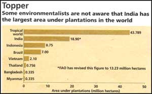
 In mid-1984, the National Remote Sensing Agency had published two sets of forest cover data, one for the period 1972-75 and another for the period 1980-82. This data shocked the nation because it revealed that during the span of these seven years, the country had lost 1.3 million hectares of forests every year. Most of the forests that were lost were natural forests as there was a very limited area under plantations at the given period (see graph: Natural forests trail).
During the 1980s, the data produced by the Food and Agriculture Organisation, an offshoot of the United Nations, shows that the rate of destruction of natural forests in the 1970s was reduced to just about a third (see graphs., Natural forests trail and Deforestation rate). Deforestation - to the tune of some 80,000 ha - actually took place in* closed and earlier unlogged broadleaved natural forests. In terms of the type of forests most affected by deforestation, the forests belonging to the dry deciduous zone were the most logged.
Related Content
- Order of the National Green Tribunal regarding concretization of river bed of Waldhuni river, Thane, Maharashtra, 12/11/2024
- Tunisia economic monitor, Spring 2024: renewed energy to the economy
- The impact of climate change on education and what to do about it
- Reducing post-harvest losses in India: farmer-level interventions and grain management strategies
- State of the climate in Asia 2023
- State and trends in climate adaptation finance 2024
