
Is the Tehri dam safe?
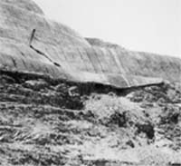 a crack on a mountainface forming part of the reservoir of the controversial Tehri dam in Garhwal, Uttar Pradesh, has once again cleaved expert opinion on the Himalayan dam's safety. An l -shaped crack has appeared on the rocky surface above one of the tunnels leading to the dam's power house. The dam authorities dismiss it as a mere construction error. However, it is not known how deep the crack is.
Several non-official experts link it to the unstable nature of the rocks and warn of possible future damage due to earthquakes. For experts, who had warned that the dam may be damaged due to the seismic activity in Tehri Himalayan foothills, the crack appears as a supporting evidence. Mired in controversy for over a decade, the 2,400-megawatt dam on the Bhagirathi river, which merges into the Ganga downstream, was meant to supply power and water to north Indian towns and cities, including Delhi.
The mountainface on which the crack has appeared had already been subjected to strengthening procedures such as rock-bolting (inserting rock bolts into rocks) and grouting (injecting cement slurry into fissured or permeable rocks). Some say it is just the plaster that has cracked open. "The plaster has come off the slope of the Raika hills above Tunnel number 3,' says S K Sharma, general manager of Tehri Hydel Development Corporation ( thdc) . The crack was noticed in March. According to him, a group of Russian consultants stationed at the dam site have taken stock of the situation.
It is the fault of engineers who did not accurately measure the depth of the rocky texture of the hill before carrying out the strengthening procedure, Sharma adds. However, he insists that there will not be any threat to the 260.5-metre-high, rock-filled main dam structure that has yet to come up.
It is the low shear strength (low load-bearing capacity) of the mountainface that made the strengthening measures necessary in the first place. Sharma notes that the crack has developed right above a portion of the mountainface where land mass caved in during rock strengthening procedures.
The affected area is a weak zone at altitude of 805m to 872m above the sea level. At full reservoir level, when water touches the 830m mark, a part of the low shear zone will be under water, says Vimal of the Tehri Bandh Virodhi Sangharsh Samiti. The mountainface on which the crack has appeared would eventually form a part of the reservoir.
Its weakness could have serious implications, critics of the dam note. P S Saklani, a Delhi University professor and an expert on Himalayan geology, points out that the dam will contain 26.2 crore cubic metres of water, and as the water passes through the tunnels there would be vibrations. Sunderlal Bahuguna, who spearheads the anti-dam movement, warns: "The Raika hills can fall anytime.' Bahuguna notes that in Italy, the adjacent walls of a reservoir fell, causing a catastrophe.
Landslides are common in the Tehri hills. There are two kinds of landslides