
Payload paraphernalia
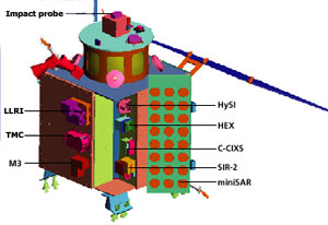 There are two scientific instruments for terrain mapping. The terrain mapping camera (TMC), consisting of three cameras at the front, back and underside, obtains a stereoscopic view of the lunar surface. It is expected to provide images with a spatial resolution of 5 m and coverage of 20 km from an altitude of 100 km. Since illumination conditions on the moon vary significantly, the camera is adjustable to provide high-resolution frames.
The second instrument for topographic mapping is a laser altimeter called lunar laser ranging instrument (LLRI). Together with TMC, it helps obtain a digital elevation map of the moon with 5 m spatial resolution. Unlike TMC, it does not depend on solar illumination and is handy in mapping the permanently shadowed areas of the moon.
Mineral mapping A number of minerals are expected to be found on the lunar surface. A typical mapping gadget will not be able to pick up chemical signals about all of them. As a result, several instruments operating in different frequencies are used for gathering data about diverse range of minerals. For instance, Chandrayaan-1 will carry three mapping instruments. The hyper-spectral imager (HySI) operates in the range of 0.4-0.92 micrometre (