
Sethusamudram ship canal project
Key data, economic, cultural, political stakes
Another issue which concerns the Tamil Nadu fishermen is the ambitious Sethusamudram Shipping Canal Project, which proposes to link the Palk Bay and the Gulf of Mannar between India and Sri Lanka by creating a shipping canal.
Sethu Samudram is the sea that separates India from Sri Lanka. With a depth of less than 10 meters across most of its extent, the sea is not sufficient for the movement of ships. This is due to the presence of the shallow region of Adam’s bridge, located southeast of Rameswaram near Pamban, that joined Sri Lanka to the continent of Asia during the last ice age. Hence, the coast of India does not have a continuous navigation channel connecting the east and west coasts. Currently the ships coming from the west coast of India and other western countries with destination in the east coast of India and also in Bangladesh, China etc have to navigate around Srilankan coast.
The SSCP project would allow ships sailing between the West to East coast of India to have a straight passage through India’s territorial waters, instead of having to circumvent Sri Lanka. In practical terms, the advantages of the canal were that the distance between Cape Comorin and Chennai would be reduced to 402 nautical miles from the prevailing 755 miles. Further, by reducing the distance between the east and the west coasts, travelling time would come down by 36 hours. It would also avoid circumnavigation of ships around Sri Lanka, thereby resulting in savings in fuel costs. As it would give India a firm grip on one of the world's most strategic and busiest sea-lanes, the Sethusamudram Project has a very important geo-political dimension.
Dredging started on 2 July 2005 and was to be completed in 180 weeks, or about 3.5 years. The Sethusamudram project required dredging 82.5 million cu.m of sand and rocks from the sea bed . In 2007, dredging in the Adam’s Bridge region had to be stopped following a Supreme Court order .When the work was stopped, only 33.99 million cu.m had been dredged. According to the experts, this stoppage has undone the work already done.
A few organizations opposed against the project on religious,environmental and economical grounds. If the canal is excavated, it will slice through the Gulf of Mannar and the Palk Bay, both of which are closed marine systems, and cause irreversible damage to a variety of marine life there. The Environmental Impact Assessment report of the National Environmental Engineering Research Institute (NEERI), Nagpur, acknowledges that the Gulf of Mannar and the Palk Bay, covering 10,500 sq km, "are biologically rich and rated among the most highly productive seas of the world". The Gulf of Mannar has been categorised as a Biosphere Reserve and its 21 islands have been declared National Marine Parks.
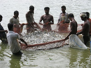
There is concern that the churning of the sediment by dredgers will smother over a hundred species of living coral reefs and generally destroy the fragile marine eco-balance of the area.The coral beds, which are sensitive biological entities, contribute to the fishery wealth. There are 87 fish landing stations between Point Calimere and Pamban in the Palk Bay, and another 40 stations in the Gulf of Mannar. The region provides livelihood to the families of several lakhs of fishermen in 140 coastal villages in Ramanathapuram and Tuticorin districts of Tamil Nadu. If coral beds’ physical environment is disturbed in a big way, the entire fish chain will be affected.
There is concern also that the oil and marine pollution associated with shipping traffic will aggravate the ecological stress already being caused by the effluents released into the Gulf of Mannar by nearby Tuticorin's chemical industries and the ash of its thermal power plant.
Meteorological researchers consider the region highly vulnerable, because of unpredictable cyclones.
Milestones
Possibly conceived in 1860 by Commander A. D. Taylor of the Indian Marines. Although it was part of the election manifestos of all political parties during elections since 1947 , the project has been reviewed many times over the years but no decision was ever made.
1955
The Government of India constituted the Sethusamudram Project Committee under A. Ramaswamy Mudaliar to examine the feasibility and desirability of connecting the Gulf of Mannar with Palk Bay and its impact on the port of Tuticorin. The committee recommended that the canal project be linked to the Tuticorin Harbour Project and that both projects be undertaken simultaneously. The cost of the joint, project was then estimated at Rs.9.98 crore. The Sethusamudram Project Committee report was, however, put in cold storage. The government sanctioned only the Tuti-corin Port project.
The government's enthusiasm to set up committees did not wane. Successive committees revised the cost of the project upwards.
January 1999
Defence minister George Fernandes announced that the government would complete the digging of the Sethusamudram channel in three years. This was backed by the prime minister Vajpayee’s assurance that his government was committed to the project.
2002
Hindu nationalists cited Nasa satellite photographs of the shoals as evidence that the events described in the Ramayana really took place, although Nasa has distanced itself from those claims.
2004
The National Environmental Engineering Research Institution (NEERI) submitted the techno-economic feasibility and environmental impact assessment report of the project.
June 2005
the United Progressive Alliance Government of India headed by Prime Minister Manmohan Singh announced the inauguration of the construction, with an approved cost of Rs.2,427.40 crore.
March 2007
Some Hindu groups launched an international campaign to halt the project, on the grounds that it will destroy the Adam’s Bridge, which Hindus believe was built by an army of monkeys to allow Lord Rama to cross to Lanka to rescue his abducted wife.
Aug-Sept 2007
Dredging in the Adam’s Bridge region had to be stopped following a Supreme Court order on 31 August and 14 September 2007 asking the government to set up an expert panel on the matter.
May 2008
The Supreme Court ordered the union government to explore the possibility of an alternative alignment for the Sethusamudram project and asked the Archaeological Survey of India to find out if Rama Setu was a man-made structure.
Religious activists favour alignment-4A saying it will not damage the Rama Setu. The Union Ministry of Environment and Forests rejected the alignment in 1998 on grounds that it was close to the marine national park of the Gulf of Mannar and will pass through the Shingle island.
July 2008
The apex court while reserving its verdict on a bunch of petitions challenging the project had asked an expert committee headed by environmentalist R K Pachauri to study the feasibility of an alternative alignment to avoid damage to the Ram Setu or Adams Bridge, made of limestone shoals. The expert committee outsourced the study to the National Institute of Oceanography (NIO). In its report, NIO said that there were not enough data to assess the impact of an alternative route.
July 2009
Work on the non-controversial Palk Straits region was interrupted
Janv 2010
The Supreme Court has given the Union government time till February 23, 2010, to clarify its stand on the Sethusamudram project. This was after the government counsel failed to give the court a definite answer on the alternative canal route suggested by the court to avoid damage to Ram Setu.
March 2011
Previously expected for 2008, the project is stalled. Only about 40% of the total project has been completed so far . The shipping ministry is ready to process a 90% escalation in the cost of the Sethusamudram ship channel project (the rise in costs is mainly a result of higher dredging prices over the years of delay in executing the project). The final decision will rest on a ruling from the Supreme Court.
Countries Position
India
Within Tamil Nadu, political factions are divided over the project. Indeed the ups and downs of the project have got linked with whether the Tamil Nadu faction constituting the State Government is in coalition with the political party constituting the Central Government in Delhi. The project is expected to provide a boost to the economic and industrial development of coastal Tamil Nadu. The project will be of particular significance to Tuticorin harbour, which has the potential to transform itself into a nodal port. Development of the canal and ports is also expected to provide increased maritime security for Tamil Nadu.
The Sethusamudram Project has a very important geo-political dimension. All the oil supplies to Southeast and East Asia that originate in the Middle East are shipped from ports in the Red Sea or the Persian Gulf. The sea-lanes from here converge in the Arabian Sea and then pass through the Gulf of Mannar and curve off the western, southern and southeastern coast of Sri Lanka.
This sea-lane then turns northeast through the Bay of Bengal towards the Malacca Strait. Eighty percent of Japan's oil supplies and sixty percent of China's oil supplies shipped on this sea-lane. Almost half of the world's container traffic passes through the choke points of this sea-lane and its branches in the Indian Ocean. The Sethusamudram Project will create an unavoidable by-pass that would inevitably divert this sea traffic through India's own maritime waters. The strategic importance of this by-pass should also be understood in the light of New Delhi's ambitions for becoming the Indian Ocean's predominant naval power.
Sri Lanka
Both Indian and Sri Lankan environmental groups so far has made several appeals to the respective governments and to the United Nations Environment Programme. Although Sri Lanka has an Environmental Impacts Assessment procedure under the Coast Conservation Department this project does not come within their jurisdictions. However, Sri Lankan environmental concerns are not addressed in the Environmental Impacts Assessment process by Indian authorities. The Environmental Impact Assessment (EIA) study on the Project carried out by India rarely refers to Sri Lanka, which is a main stakeholder In number of occasions environmental groups urged to conduct a joint Indo-Lanka Environmental and Social Impacts Assessment. But Indian approach is very defensive.
The Sri Lankan government, even as late as 2005 has been demanding the establishment of a standing joint mechanism for exchange of information. It wanted to set up a common data base on the hydrodynamic modelling, environmental measures and impact on fisheries resources, fisheries dependent communities and measures to cope with navigational emergencies. The discussions, however, has not led to the achievement of the level of transparency in the implementation of the project as these concerns still remain unsettled. . The reason could be that the government is tempted by the proposal to make a barrier for terrorist movements.
Leading institutions, NGOs, experts
The Tuticorin Port Trust
Sethusamudram Corporation Limited
Coastal Action Network
Dakshin
Related Content
- Question raised in Rajya Sabha on review of Sethusamudram Shipping Canal Project 01/12/2014
- Should Sethusamudram Project get the go ahead?
- NIO device to assess environmental impact
- Table NIO expert group report on Sethu: Swamy
- Karunanidhi recalls efforts on Sethu project
- Part of Sethu work will be over before April 2009