Averting disaster
 geographic Information Systems ( gis ), a computer software for mapping geographical data for civic and environmental planning, is now being used in Sikkim and Darjeeling for landslide management and mitigation. One of the major problems in mitigating a disaster is the lack of warning. The advantage of having a gis model is that it can identify landslide-prone areas.
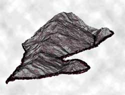
Last year, the Sikkim government invited Delhi-based Ramtech Corporation to map the entire state to create a three-dimensional computer model, called the digital terrain model ( dtm). Inspired by the Sikkim's experience, the Darjeeling Gorkha Hill Council has also recently invited the same company for a similar exercise. Says P K Pandey of Ramtech Corporation: "The model gives a visual picture of the problem areas at a glance. It can be used even by non-technical persons.'
Experts made a base map collating contour maps of the Survey of India, satellite imagery of the Indian Space Research Organisation ( isro ) and aerial photographs provided by the defence personnel. Then they fed the data of landuse, gradient, soil characteristics and meteorological parameters of the past fifteen years into the computer. They also noted engineering details such as subsoil characteristics, local geology, folds and faults, drainage patterns and capacity, surface runoff and soil water relations. Road networks, building types, forest density, forest type, species
Related Content
- Regional drought response plan for the Horn of Africa: 2023
- Groundswell Africa: a deep dive into internal climate migration in Nigeria
- Order of the National Green Tribunal regarding blast in the chemical factory run by Yashyashvi Rasayan Pvt. Ltd. at Dahej, District Bharuch, Gujarat, 03/02/2021
- Whatever it takes- A rapid and massive increase in aid is needed to save millions of lives and bring our divided world together amid the coronavirus pandemic
- Illegal mining puts Joburg on brink of disaster
- Somalia drought impact and needs assessment: synthesis report
