Model flood control
 THOUGH floods cannot be wished away, they could soon be whisked away. A group of British computer experts is trying to model river flows so as to predict the best way to control flooding (New Scientist, Vol 141, No 1907).
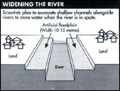
When a river spills over its sides, some of the water is absorbed by the soil, arresting its ominous march. Researchers believe if this action can be enhanced, it would be far more expedient than customary strategies like straightening rivers, heaving their banks and deepening the river bed. The idea is to dig an artificial flood plain well away from settlements.
The scientists plan to excavate what they call a two-stage channel. The first is the natural course of the river itself and the second is a higher but shallower channel 10 to 15 metres wide, flanking the river. This second channel would store water temporarily when the river is in spate.
However, modelling the interaction of the river and its flood plain is not easy. Building a model of a 500-metre stretch of river is prohibitively expensive, let alone laborious. For example, a 1:25 scale model of a 250-metre stretch of river would cost L10,000.
A computer model designed by Gareth Pender of the University of Glasgow takes about 6 hours to predict the water level and flow along just 500 metres of river. However, Pender intends to use data from physical models and real rivers so that the model works faster and for longer stretches of a river. The researchers are hopeful that in 3 years they will be able to generalise the model for almost any river in Britain.
Related Content
- Report by the State Pollution Control Board, Sikkim on CETP/STP, 19/10/2023
- Greening water risks: natural assurance schemes
- Progress report on steps taken to stop the unscientific dumping of municipal solid waste into the Hokersar wetland, Wular lake and Kreentchoo-Chandhara wetland in district Budgam in Jammu and Kashmir, 18/08/2020
- Order of the National Green Tribunal regarding rejuvenation of river Yamuna, 22/01/2020
- Impact of a changing climate, land use, and water usage on Europe’s water resources: a model simulation study
- The global value of mangroves for risk reduction
